Take a journey towards the centre of the Earth and walk amongst the remains of an ancient volcano that erupted over 60 million years ago.

Visit the most westerly point of mainland Britain to discover how this ancient volcano, along with three other nearby volcanic centres formed the dramatic landscape of the Ardnamurchan peninsula and the surrounding Hebridean islands of Rum, Mull and Skye.

Find out about the pioneering geologists who described the volcanic centres and ring intrusions of the Ardnamurchan volcano. Discover how the story continues with new insights into the internal structure and inner workings working of this ancient volcano.

Whilst on the Ardnamurchan peninsula, take time to discover first hand the geology and landforms created by the Tertiary magmas that intruded into the ancient rocks that characterise the West Highland peninsulas. The “Great Eucrite” which forms an almost complete ring of hills is an excellent example of an annular intrusion and dominates the peninsula. Marvel at fine exposures of Moine schists, the products of marine shales and mudstones that were transformed by extreme heat and pressure during huge earth upheavals. Go on a fossil hunt to discover the remains of long extinct molluscs that once lived in the oceans during the time of the dinosaurs.

Head south on a geological excursion to the Morvern peninsula to discover more ancient metamorphic and sedimentary rocks, volcanic landforms and Jurassic fossils, on a rock safari that spans huge geological timescales.

It is time to delve into the geological history of the West Highlands and have a hard rock adventure.


1

 ( Ardnamurchan Peninsula )
nearest village:  Kilchoan
grid ref: NM416674

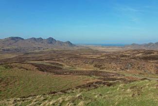
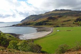
Ardnamurchan Point is the most westerly point on the British mainland and sits on a dark-coloured, coarse-grained, basic intrusive igneous rock. This rock was formed from magma deep within the earth and has relatively large crystals composed mainly of pale plagioclase feldspar with quartz. The gabbro has been exposed through erosion and is characteristic of most of the west end of the Ardnamurchan Peninsula.

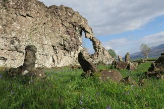
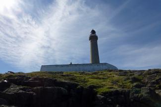
Take time to visit The Ardnamurchan Lighthouse and Exhibition Centre. The exhibition centre at the Ardnamurchan lighthouse has some interesting displays about the geology of…


nearest village:  Kilchoan
grid ref: NM469678

Take a trip to the beautiful beaches at Sanna Bay and travel through the roots of an ancient volcanic centre (volcanic centre 3), the last of the three volcanoes to erupt in the area in the early Tertiary.

The remains of this volcanic centre (centre 3) are best seen from a track heading towards the deserted village of Glendrian, approximately 1km south-east of Achnaha. However, details of all three volcanic centres and their origins can be found on the Lochaber Geopark Interpretation Board at Mingary Pier.

Take the single track road B8007 towards Kilchoan on the…


3

 ( Kilchoan )
nearest village:  Kilchoan
grid ref: NM469625

Kilchoan is one of the few places on the Ardnamurchan peninsular where the aspiring fossil hunter has a good chance of discovering some ancient marine life. The fossil remains of marine Cephlaopod molluscs, such as ammonites and the belemnites, which inhabited the warm tropical seas can be found the Jurassic limestone and shales around Ormsaigbeg and Kilchoan Bay.

Belemnites belong to an extinct order of squid-like cephalopods that existed from the Late Triassic to Late Cretaceous. Typically, only the elongated and bullet shaped rostrum (guard) is preserved in the rocks. Belemnites…


4

 ( Glenborrodale )
nearest village:  Glenborrodale
grid ref: NM566672

The rugged profile of Ben Hiant dominates the Ardnamurchan peninsula being the highest mountain on the peninsula at 528 metres. It is the remains of an ancient volcano that erupted over sixty million years ago and epitomises the complex geological history of the Ardnamurchan peninsula.

Fine views of Ben Hiant are afforded from the car par/picnic site situated above the lovely sandy bay at Camus nan Geall by Ardslignish on the B8007, a few kilometres west of the Ardnamurchan Natural History Centre at Glenmore.

There is an excellent interpretation board at the far end of the…


nearest village:  Lochaline
grid ref: NM604467

Take the lovely coastal road between Lochaline and Drimnin and seek out The Wishing Stone on the shores of the Morvern peninsula. Take time to admire this impressive rocky outcrop with its large angular hole and follow the ritual to make your wish come true.

The Wishing Stone is part of a dyke that intruded verically into a fissure in the surrounding bedrock around 60 million years ago. Subsequent erosion of the surrounding bedrock left the dyke exposed as a prominent rocky outcrop with a large angular hole in the centre.

Although the Wishing Stone is a natural feature, it…


nearest village:  Lochaline
grid ref: NM680449

Take the road to Lochaline on the Morvern peninsula to explore ancient metamorphic rocks, Triassic sandstones, basalt lavas and pure white silica sands. Take a fossil excursion to discover an ancient marine mollusc that lived during the Jurassic period.

The key geological sites associated with this trip are located in the vicinity of the small rural village of Lochaline, situated on the north shore of Loch Aline. However, as you travel south along A884 you will have an opportunity to see exposures of granite, Moine psammites (metamorphosed sandstone), mica schists (metamorphosed…


nearest village:  Lochaline
grid ref: NM693460

Take a lovely walk along the southern shore of Loch Aline to search for Jurassic fossils along a burn that runs through a Pabay Shale Formation. Admire the fine coastal views and beautiful deciduous woodland that skirts the track. You can also take a hike to stunning waterfall, named in honour of Alfred, Lord Tennyson, who was a regular visitor to Old Ardtornish House.

The fossils found in the burn are Gryphaea (Devil's toenails), an extinct genus of Jurassic bivalves that lived on the sea floor. The Gryphaea consist of two unequal values (shells), a large heavy curved shell and a…


8

 ( Sunart )
nearest village:  Strontian
grid ref: NM859663

Take a rock safari to discover how a small rural village in the West Highlands gave its name to a lustrous whitish yellow crystalline mineral and a metal element that lights up the night sky.

Around 250 years ago, various minerals were injected into pre-existing fractures in the Moine schists around Strontian and Morvern. One such mineral was galena, lead (II) sulphide, which is the principal ore of lead and an important source of silver. The galena was discovered in the hills around Strontian in 1722 by Alexander Murray; this led to the opening of a lead mine in 1725. By 1730, the…